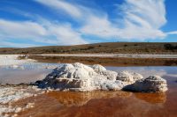
Well, I got out to Lake Torrens to photograph the salt encrustation. Actually, Lake Torrens at this point, and most places, isn't all that salty. It's more like a light pink coloured crust of dried, salty mud, stretching into the distant mirage with the Flinders Ranges in the background, rising above the shimmering illusion of water.
From the banks of Good Friday Dams, I could pick out the two creeks, one on either side, North Woodforde and Woodforde. The creeks are delineated by the myall and mulga trees that line them. So I took a compass bearing on what looked to be a pass through the hils and made a waypoint on the GPS.
Before me lay a kilometre or so of gibber plain. Then the the two creeks converged making a flood plain half a kilometre wide, in places strewn with water worn rocks and in others I found a sandy path which was sometimes interspersed with salt bush which had resisted the wind and water erosion, making for a pretty rough ride whichever way I went.
Was the site before me at the mouth of North Woodforde Creek worth the effort? Judge for yourself. You hardly need to be told what I think.
The salt incrustation seems to be different where ever the arid region creeks meet Lake Torrens, so over the years I've accumulated a varied portfolio of salt images.
In flood times, massive volumes of fresh water rush toward the muddy bed Lake Torrens, partially filling Australia's second largest salt lake. The flood scours out the creek bed near the lake, leaving a fresh waterhole below the level of the lake, maybe up to a foot or two deep.
As the weeks and months roll by, the salty water from the Lake Torrens water table infiltrates the fresh waterhole and as evaporation lowers the water level, the water soon becomes super saturated and the salt begins crystallizing out.
The wind causes ripples that splash any twigs and rocks with super saturated salt water which dries in the wind and sun to form salt crystals. The salt also crystallizes out on the muddy bed of the waterhole, leaving a tough crust of salt both above and below the water level as evaporation continues both in the creek and the lake.
In the past, I've noticed only perfectly cubed salt crystals but in smaller waterholes, approaching the mouth of these creeks, I found crystals in irregular matted form and wondered whether this was due to other minerals of different crystalline structure.
Many of the images presented here were taken from a low level, quite close up, simply holding the camera in what appeared to be the right spot, leading to a high failure rate, especially with sloping horizons.
For me, the unlimited, random forms that I find in the salt encrustations of the arid region creeks and lakes are a refreshing inspiration and I repeatedly travel to this region in search of more. Only it's not more of the same; every visit is unique!
Your comments are invited below. I'd love to interact with you over these images!


